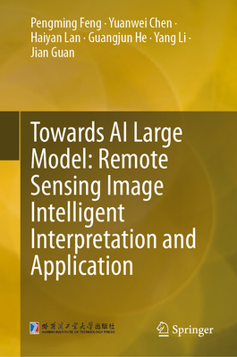
Towards AI Large Model: Remote Sensing Image Intelligent Interpretation and Application
暫譯: 邁向 AI 大型模型:遙感影像智能解讀與應用
Feng, Pengming, Chen, Yuanwei, Lan, Haiyan
- 出版商: Springer
- 出版日期: 2026-05-26
- 售價: $8,470
- 貴賓價: 9.5 折 $8,046
- 語言: 英文
- 頁數: 298
- 裝訂: Hardcover - also called cloth, retail trade, or trade
- ISBN: 9819558786
- ISBN-13: 9789819558780
-
相關分類:
Large language model
海外代購書籍(需單獨結帳)
相關主題

商品描述
商品描述(中文翻譯)
本書從遙感影像智能解釋與應用技術的發展現狀開始,系統性地介紹了該領域的主要進展及其應用,重點關注遙感影像的智能質量提升、智能擴展與樣本增強、物體檢測、細粒度目標識別、語義分割、多模態遙感影像聯合智能解釋,以及智能解釋與應用平台。隨著大型模型和人工智慧技術的快速發展,並在中國高解析度地球觀測系統國家科技重大專案等重大專案的支持下,作者及其團隊在遙感影像智能解釋與應用技術領域取得了一系列研究成果。
作者簡介
Pengming Feng, Ph.D., senior engineer, master's supervisor, researcher at the National Key Laboratory of Space-Ground Integrated Information Technology at the 503rd Institute of the China Academy of Space Technology. He has been deeply involved in the research of satellite remote sensing intelligent interpretation technology and has successively led more than 10 pre-research and modeling projects, including the National Natural Science Foundation. He has published more than 30 papers and obtained more than 20 patents.
Yuanwei Chen, Master's degree holder, researcher, system designer at Aerospace Xingxing Technology Co., Ltd. He has been deeply involved in research on satellite ground system and application overall technology, and has been responsible for delivering more than 10 engineering models at home and abroad. He has published more than 10 papers.
Haiyan Lan, Ph.D., lecturer, master's supervisor, is a faculty member of the School of Computer Science and Technology, Harbin Engineering University. She has been engaged in research on signal processing and deep learning methods, and has published over 20 academic papers and obtained over 10 patents and software copyrights. She has also won the Second Prize in the Natural Science and Technological Academic Achievement of Heilongjiang Province.
Yang Li, Master's degree holder, engineer, is a system designer at Aerospace Xingxing Technology Co., Ltd. He has been deeply involved in the research of overall technical solutions for remote sensing satellite ground systems and has participated in completing more than 8 engineering models. He has published more than 8 academic papers and patents.
Jian Guan, Ph.D., associate professor, master's supervisor, is a faculty member of the School of Computer Science and Technology, Harbin Engineering University. He has been engaged in research on target detection/recognition methods in remote sensing and deep learning theory and applications for a long time. He has published more than 50 academic papers and applied for and obtained over 10 invention patents.
Guangjun He, Ph.D., senior engineer, master's supervisor, is the head of the Space Information Fusion Research Room at the National Key Laboratory of Space Integrated Information Technology at the 5th Research Institute of China Academy of Space Technology (CAST), where he has been engaged in research on satellite remote sensing application technology for a long time. He has hosted over 20 national natural science foundation projects and published more than 40 academic papers. He has also been granted over 30 patents.
作者簡介(中文翻譯)
馮鵬明,博士,高級工程師,碩士生導師,中國航天科技集團第五研究院國家空間綜合信息技術重點實驗室研究員。他深度參與衛星遙感智能解釋技術的研究,先後主持了包括國家自然科學基金在內的10多個前期研究和建模項目。他已發表30多篇論文,並獲得20多項專利。
陳元偉,碩士學位持有者,研究員,航天星星科技有限公司系統設計師。他深度參與衛星地面系統及應用整體技術的研究,負責交付國內外10多個工程模型。他已發表10多篇論文。
藍海燕,博士,講師,碩士生導師,哈爾濱工程大學計算機科學與技術學院的教職員。她從事信號處理和深度學習方法的研究,已發表20多篇學術論文,並獲得10多項專利和軟體著作權。她還獲得了黑龍江省自然科學與技術學術成就二等獎。
李揚,碩士學位持有者,工程師,航天星星科技有限公司系統設計師。他深度參與遙感衛星地面系統整體技術解決方案的研究,參與完成了8個以上的工程模型。他已發表8篇以上的學術論文和專利。
關健,博士,副教授,碩士生導師,哈爾濱工程大學計算機科學與技術學院的教職員。他長期從事遙感中的目標檢測/識別方法及深度學習理論與應用的研究,已發表50多篇學術論文,並申請獲得10多項發明專利。
何光軍,博士,高級工程師,碩士生導師,中國航天科技集團第五研究院國家空間綜合信息技術重點實驗室空間信息融合研究室主任。他長期從事衛星遙感應用技術的研究,主持了20多個國家自然科學基金項目,已發表40多篇學術論文,並獲得30多項專利。